The Garmin Colorado 400t
Take on the trails with Colorado 400t. This rugged, advanced handheld is packed with detailed topographic maps for all your hiking adventures not to mention 3-D map view, a high-sensitivity receiver, barometric altimeter, electronic compass, SD™ card slot, picture viewer and color display. Exchange tracks, waypoints, routes and geocaches wirelessly between similar units. When the going gets tough, Colorado leads the way.
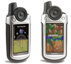
Explore Backcountry in 3-D- Colorado's preloaded U.S. topographic maps, 3-D map view and a built-in worldwide basemap with shaded relief give you all the tools for serious climbing or hiking. Map detail includes national, state and local parks and forests, along with terrain contours, elevation information, trails, rivers, lakes and points of interest. Just in case you’re wondering how steep that hill really is, Colorado’s 3-D map view helps you visualize your surroundings — giving you a better perspective of the elevation.
Share Wirelessly- With Colorado 400t you can share your waypoints, tracks, routes and geocaches wirelessly with other Colorado users. Now you can send your favorite hike to your buddy to enjoy or the location of a cache to find. Sharing data is easy. Just select “send” to transfer your information to other Colorado units.
Rock on. Find Fun- Intuitive and fun, Colorado features a Rock ‘n Roller® input wheel for easy one-handed operation and supports Geocaching.com GPX files for downloading geocaches and detail straight to your unit. Customize Colorado's interface based on your favorite activity. Even show off photos of your excursions with its picture viewer. Slim, lightweight and waterproof, Colorado is the perfect companion for all your outdoor pursuits.
Keep Your Fix- With its high-sensitivity, WAAS-enabled GPS receiver, Colorado 400t locates your position quickly and precisely and maintains its GPS location even in heavy cover and deep canyons. The advantage is clear — whether you’re in deep woods or just near tall buildings and trees, you can count on Colorado to help you find your way when you need it the most.
Get Your Bearings- Colorado 400t has a built-in electronic compass that provides bearing information even while you're standing still, and its barometric altimeter tracks changes in pressure to pinpoint your precise altitude. You can even use the altimeter to plot barometric pressure over time, which can help you keep an eye on changing weather conditions.
Plug in and Go- Conveniently plug in optional preloaded SD cards for all your outdoor activities on land or water (see maps tab for compatible maps). Just insert a MapSource card with detailed street maps, and Colorado provides turn-by-turn directions to your destination. Add detailed trail information by purchasing additional TOPO maps for national parks and more. The card slot is located inside the waterproof battery compartment, so you don't have to worry about getting it wet.
Get Connected- You've been busy exploring and now you want to store and analyze your activities. With a simple connection to your computer and to the Internet, you can get a detailed analysis of your activities and send tracks to your outdoor device using Garmin Connect™. This one-stop site offers an activity table and allows you to view your activities on a map using Google™ Earth. Explore other routes uploaded from over 12 million customers and share your experiences on Twitter® and Facebook®. Getting started is easy, so get out there, explore, and share.
Colorado 400t: For adventure in any direction.
